A Visual Lesson In Mindful Hiking From Sweden's Barron Fjäll Landscape

A Visual Lesson In Mindful Hiking From Sweden's Barron Fjäll Landscape

Author
  • Emma Ingemann, Bea Hansson
Photographer
  • Emma Ingemann, Bea Hansson

Camera
  • Mamiya 645, Olympus Mju ii, Olympus AF1, Canon AE1
Film

Published: 09-24-2025

About the author

Guest Contributor
Guest Contributor
Limited-edition content from our global network of photographers, journalists & adventurers.

Emma Ingemann is an art director and photographer currently studying to become a mountain leader. You can find her on Instagram @ingenemma. Bea Hansson is a designer and stylist who lives for skiing and hiking. Find her on Instagram @beahansson. They both live in Åre, Sweden.

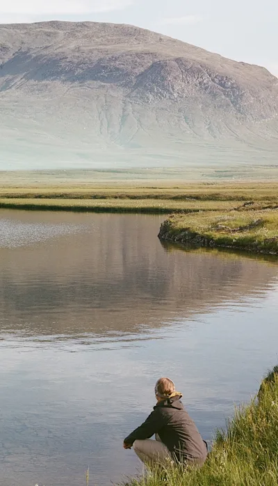
About an hour drive from the popular ski resort in Åre you’ll find Bunnerfjällen, a 'fjäll' massif. There really isn’t a good translation for the Swedish word, which refers to a barren summit above the treeline. You can say “mountain,” I guess, but that doesn’t really capture the singular beauty of these northern Scandinavian peaks.

My friend Bea and I both live in Åre, and have been training to take the Swedish “fjälledarnorm,” a mountain guide certification that allows you to lead people into the Swedish mountains. In order to meet the standard one must master 16 different skills, including first aid, avalanche training, and navigation. You must also spend 60 days in the fjäll with at least 20 nights in a tent. And so, an idea was born.

We had been planning a hike in the area as a way to explore Bunnerfjällen, which is unreachable by trail. Given our shared creative backgrounds—we met in a photo studio in Stockholm where Bea was working as a styling assistant and I was a junior art director—it only felt natural to try and document the trip. In order to share the story we reached out to Klättermusen who loved the idea and helped out with gear.

sweden-mountains-emma-and-bea-NEW-drinking-coffee-on-rock

Our hike would take us through parts of Jämtland, the middle of Sweden. We started at Storulvåns fjällstation, a classic connecting point to reach multiple routes and fjäll. But the hike doesn’t really start until you’ve waded over the nearby Handölan stream and made it above the treeline. Here, we experienced our first ‘Kalfjäll,” a high mountain plateau where trees can’t grow. Instead, the land opens into a wide, windswept expanse of rock, heather, moss and lichen.

Hiking in open terrain like this brings a certain calmness. You become aware of your surroundings as the vast landscape gives you a feeling of being both close and far away at the same time. Honestly, at points, the openness made us feel a bit exposed. Especially as storms we were expecting started to appear on the horizon.

We walked between the mountains Stråatantjahke and Laptentjahke until we made it to Norra Bunnersjön, a lake divided in two, our camp spot for the night. This was made possible by the Swedish policy of Allemansrätten, which allows you to set camp almost anywhere on its land, provided you show respect for anything you encounter.

sweden-mountains-emma-and-bea-NEW-map-point

sweden-mountains-emma-and-bea-NEW-portrait

In this case passing through land for reindeer herding owned by the Sami people. In general, we tried to keep the hiking distances each day quite short, so that we had plenty of time to capture film along the way.

Quite early on, we both realized we had never hiked like this. Being able to move slowly, without rushing to another point on the map, allowed us to notice details we otherwise might have missed. Things like cloudberries and beautiful patterns in nature might not have been apparent to us if we had been chasing miles. This quickly became the subject of all conversations. Being out hiking at this pace gave us a new appreciation for what we have.

sweden-mountains-emma-and-bea-NEW-antler-vertical

sweden-mountains-emma-and-bea-NEW-hanging-clothes-vertical

After leaving Norra Bunnersjön behind, we followed the valley over the fen and made it up to Västra Bunnerstöten. Once higher on the kalfjäll, there was almost no vegetation left but moss, a completely new view.

Walking back down in the valley, we followed the mountain stream and eventually reached the tree line again. At this point, the storm we had been expecting actually hit, and we had to stop to put on our rain gear. Having to stop like this is pretty typical, but we quickly saw something you rarely find: chanterelles, the gold of the forest. We filled our pockets and the one last dry bag we had, then happily walked the last stretch until we reached Storulvåns fjällstation once again. Leaving, we felt reminded of how privileged we are in Sweden to have Allemansrätten that allows us to cross land freely and for the opportunity to take things slow. It reminded us that we should always try not to rush whenever we can.


sweden-mountains-emma-and-bea-NEW-reindeer-crossing

sweden-mountains-emma-and-bea-NEW-putting-shoes-on

sweden-mountains-emma-and-bea-NEW-bw-walking-with-bag

sweden-mountains-emma-and-bea-NEW-carrying-stuff-on-rocks-vertical

sweden-mountains-emma-and-bea-NEW-in-tent-portrait-vertical

sweden-mountains-emma-and-bea-NEW-hunched-behind-tent

sweden-mountains-emma-and-bea-NEW-cloud-berry

sweden-mountains-emma-and-bea-NEW-testing-water

sweden-mountains-emma-and-bea-NEW-grove-of-trees

To experience a different part of Scandanvia, consider sailing around Norway's North Cape, the northernmost point of Europe.